When visibility breaks down, so does decision-making.
Modern sensing and navigation systems struggle in the environments that matter most:
Thermal scenes flatten when objects approach thermal equilibrium
Low-signature targets disappear into clutter at range
GPS becomes unreliable or unavailable
Wide-area surveillance becomes very expensive to scale
Identification degrades in low light and long-range conditions
Critical information is there, but conventional systems can’t extract it.
Standard Thermal
Polarization (DOLP)
Polaris extracts what others miss.
Polaris systems combine polarization, infrared, visible imaging, and celestial cues to reveal structure, enhance contrast, and recover signal in low-information environments.
Instead of relying on a single modality, Polaris solutions are designed to:
Increase signal-to-clutter ratio
Reveal features hidden in low-contrast scenes
Maintain performance across degraded or denied conditions
The result: actionable insight where conventional sensing breaks down.
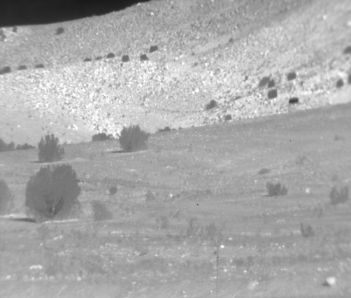
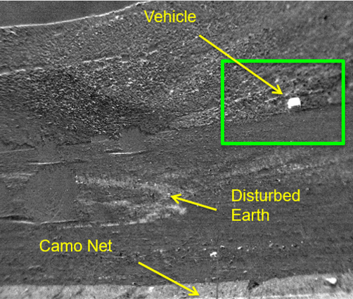
Long Wave Infrared (LWIR) imaging is inherently a 24-hour solution, but there are scenarios where objects are too close to thermal equilibrium with their surroundings to be detected by standard thermal imagers, or they have similar thermal profiles to natural clutter. Polarization reveals structure in low-contrast thermal scenes and highlights man-made objects that would otherwise blend in, turning low-contrast or cluttered imagery into actionable insight in real time.
Key Capabilities
Reveals hidden objects in thermally uniform/cluttered scenes
Enhances contrast, texture, and feature visibility beyond standard LWIR
Improves detection confidence in operational environments
Real-time clarity without added operational burden
Modular SDK enables cross-platform integration
How It Works
Division of Focal Plane (DoFP) polarimetric filtering increases signal-to-clutter ratio, improving frame-by-frame interpretability in thermally uniform or visually complex LWIR scenes.
Polarization increases situational awareness, revealing important details that cannot be detected with standard thermal imaging.
SKYPASS GEN4
Scalable Navigation Without GPS
SKYPASS GEN4 delivers next-generation GPS-independent navigation with a modular, scalable architecture. It fuses celestial and polarization-based cues to maintain reliable positioning in GPS-denied environments while improving manufacturability, reducing cost, and enabling flexible deployment across platforms.
Key Capabilities
GPS-denied and degraded navigation capability
Works day, night, twilight, and partial sky visibility
Modular channel architecture for mission-specific configurations
COTS-based design reduces cost and complex integration
Modular SDKs allow cross-platform integration
How It Works
Fuses star-field imaging, solar/lunar tracking, and sky polarization for drift-free navigation across variable conditions.
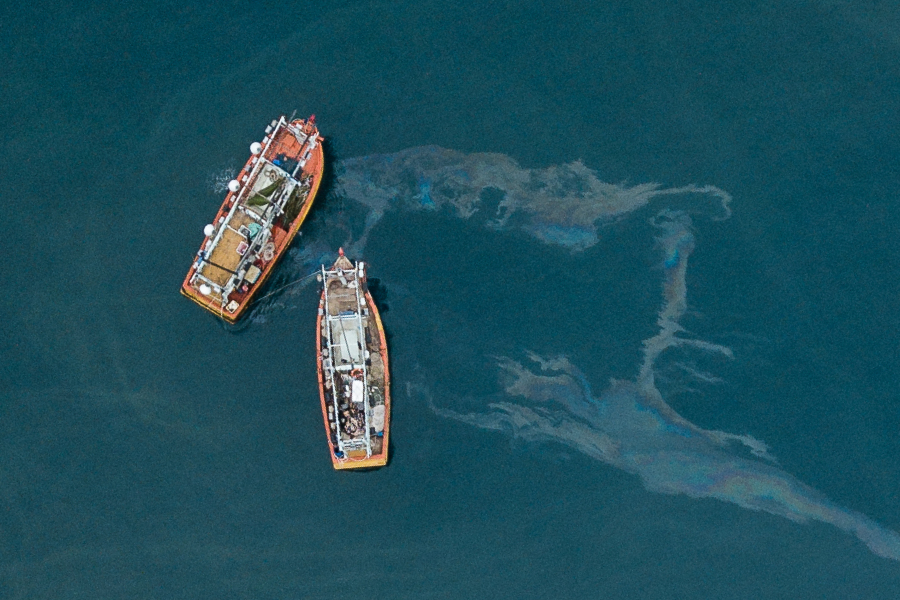
Oil sheens blend into water and are often missed. PODS uses LWIR polarization to separate oil from water so spills become clearly detectable in real time, day and night.
Detects thin oil sheens conventional systems miss
Accelerates spill detection time, reducing environmental impact, response cost, and liability
Discriminates between oil and water in complex marine scenes
Reduces false positives in dynamic conditions
Real-time detection and alerts
Estimates area of spill
PYXIS VIS
Information-rich imagery that expands detection and discrimination capability.
Pyxis Vis incorporates polarization into RGB technology in a way that increases image detail without overshadowing existing RGB imagery and allows the resulting imagery to use existing image processing libraries.
Additional modality for targets that otherwise have little contrast with surroundings
Increases DRI capability in cluttered scenes
Extends maritime situational awareness and search and rescue capability
Supports passive, low-risk surveillance
WASS
Wide-area hemispherical surveillance
WASS enables high-resolution, cost-effective hemispherical monitoring using a stop-and-stare scan architecture.
Wide-area long-range detection
Low-cost Radar alternative
Can be combined with any camera
Persistent, scalable monitoring
IRIS
Long-range day/night identification
In zero light or long range, identification breaks down. IRIS enhances imaging with a portable, highly stable, eye-safe IR illuminator to improve feature clarity and matching reliability.